'The Coorong is spirit- peace of isolation; regeneration of solitude; therapy of loneliness. Spirit that man desperately needs'.
So wrote South Australian author Colin Thiele fifty years ago in 1972 - and his sentiments are just as fitting today. Looking forward to capturing that sense of isolation and peace, we decided to escape the neighbourhood and head east for the day, ignoring the observation of French explorer Nicolas Baudin, who in 1802 declared the area ' wretched and unpleasant'. It's a couple of hundred kms from home so we set off early in joyful spirits.
In geographical terms, the Coorong is a huge saline lagoon 140kms long beginning a little east of Goolwa where the Murray River enters the sea and stretching all the way to the coastal town of Kingston in the far south-east of the state; the lagoon is separated from the Southern Ocean by a long (very long) neck of sand dunes and I guess that at first sight it does look a little underwhelming. However, Colin Thiele evoked a much more evocative sense of place in his 1964 novel Storm Boy.
“Storm Boy lived between the Coorong and the sea. His home was the long, long snout of sandhill and scrub that curves away south-eastwards from the Murray Mouth. A wild strip it is, windswept and tussocky, with the flat shallow water of the South Australian Coorong on one side and the endless slam of the Southern Ocean on the other.”
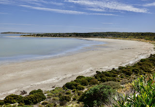
This beautiful coastal wilderness is home to many migratory birds and waterfowl, including my favourite - pelicans. It is also hugely significant to the Ngarrindjeri people who have called this their home for thousands of years. From the ever-shifting steep dunes, the landscape is flat and consists of lagoons, narrow waterways, small lakes, salt pans, and native flora that includes scrubby tussocks, spinifex, mallee, tea trees and a range of saltmarsh species such as samphire. This wetlands ecosystem is, rightly, a protected area. This photo is a good example, showing dunes (although these have been heavily vegetated), a lagoon and typical plants.

We had previously visited some of the Coorong way back in 1998 when we did a guided tour of the far south-east portion, and again in 2016 when we did a cruise from Goolwa where the lagoon begins and explored the sand dunes. This time, we were doing, as I termed it, 'the middle bit'.
The start of our Coorong escape is the lovely lakeside town of Meningie approximately 150kms from Encounter Bay. It's quite an adventure to even get there as we first have to navigate around Lake Alexandrina into which the Murray River finally drains. It's a mighty obstacle and it takes ages to drive along the shoreline. At the tip of the lake is the small town of Wellington where we have to take the car ferry to cross the Murray and continue on our journey. I love this tiny trip as the cable pulls us gently across the stretch of river. Then it's 50 kms to Meningie.

Meningie is called 'The Gateway to the Coorong'. It nestles on the freshwater Lake Albert (a smaller lake next to Lake Alexandrina that is also fed by the Murray) and is a bustling town with all the amenities needed - including a top notch bakery where we refuelled with a hot chocolate and coffee and suitable sugary treats for each of us. The lovely lady at the Information Centre supplied us with maps, brochures and information on spots we wouldn't have otherwise known about. This map shows Lake Alexandrina, Meningie and Salt Creek.

We were aiming for Salt Creek, a tiny settlement where we had planned our first walk, but stopping off at places along the way that had been suggested to us. I loved the drive. It was big sky country, with acres of grazing land to the left and the scrubby coastal vegetation to the right, all of it encased by the huge arc of blue sky stretching forever overhead. I was amazed at the number of pastoral properties we passed - nothing more than a gate, a name on a sign, and a lonely drive disappearing into the far distance. But pastoralists had first settled here in the 1840s, establishing large holdings on which to graze their cattle and sheep and grow crops. Some were successful but many encountered immense struggles and hardship in this isolated and unproductive-looking area. I can only imagine what the Ngarrindjeri peoples thought as the environment changed considerably to cater for this new endeavour. I wondered how many of these properties I was seeing were the original landholdings.
Our first stop was Parnka Point, a small spit of land jutting through the northern lagoon with road access. Here we could see the lagoon on both sides. It was peaceful. The landscape stretched before us. Not a soul in sight.


We continued on until Salt Creek came into view.


A little further on was a small motel.
We had elected to do the 3.5kms loop walk around the lake - the Ngrugie Ngoppun Walk, 'good walk' in the Ngarrindjeri language. We walked through an overgrown thicket, a theatrical warm-up to what lay beyond.


Which was a vast landscape of reeds and marsh plants with the lake in the near distance surrounded by thick shrubs and trees.

Wild, beautiful, unspoilt are clichés that sprang to mind. The track was firm and made for an easy stroll.

This was supposed to be a birdwatchers' haven but, although we were constantly hearing the tweets, warbles and chirps of different types of birds, we didn't actually see any. We wandered on, a gentle warmth from the sun, an incredibly blue sky with wispy clouds and the glistening lake.


This is where I spotted the tribute plaque to Colin Thiele.


We rounded the lake and crossed the water via the concrete walkway, luckily spotting the sign that indicated the walk. On we went. I loved this field of plants that had obviously adapted well to the harsh, salty conditions. [Note: Oops. I have since been informed by my environmental friend BB that this is the dastardly sea spurge that is a weed devastating the sand dunes in southern Australia, but it is difficult to control.]

The signs were now getting more difficult to find and the track became rockier.

We rested for a spell, taking in the views over the flat landscape...

... and taking photos.

And then... disaster. No more signs. No more well-trodden track. No cleared spaces. No sense of where we were. The track was labelled 'a loop' so we thought we'd have returned close-ish to the place where we'd started. But no. We were on the other side of the lake. We struggled on a bit more until we could see in the distance cars going along the highway- a very good sign. Steve decided that we should take the shortest route to the road across the salt pan (probably very non-environmental), but as good a solution as any. Off we went.

A bit of reed bashing.

And finally, the road.
We read later that 'The track is well signposted up to a point and then becomes indistinct'. You could say that again. Annoyed but thankful for our survival, we hopped in the car and headed for the next destination: Chinaman's Well.
When gold was discovered in Victoria in the 1850s hundreds of Chinese made their way to the goldfields; many landed in South Australia to avoid paying the tax imposed by the Victorians for people entering their colony. This meant a hard slog across inhospitable country with little water. The ever-resourceful Chinese built a number of wells on the way so they could source fresh water along their route. One of these wells has been preserved. There's a small loop track with interpretive signs along the way, bringing the history of the site vividly alive. First up was a sign explaining how they carved limestone from a quarry to construct the well. There's a walkway leading to a shallow depression that clearly shows where the lid of the well was carved.

The signs helped us visualise the difficulties the Chinese faced.


Steve dug out some photos from our previous trip which proved to be rather interesting in that they show how different the presentation of the well is now. Then it was surrounded by a protective wire cage and we could walk right up to it. Here are a couple of photos from that time.


Our last stop was on the homeward journey where we visited Jack Point where you can view the huge pelican population. You can see the viewing platform in the distance. We didn't take the walk there (I think we were just too tired) but saw flocks of pelicans flying overhead - a wonderful sight.


A fabulous day out.